3 week itinerary
Week 1
Day 1

Palenque
Morning: Having arrived in Palenque the previous night, rise early and take advantage of the entire day in Palenque. Set in the foothills of the Tumbalá mountains of Chiapas, Mexico, Palenque, recognized as a UNESCO World Heritage Site, is perfectly situated on a ledge overlooking the swampy plains that stretch northward all the way to the Gulf coast. Begin your day by wandering around the city as a whole to gain a sense of appreciation for the distinct style of architecture at Palenque. You will notice that most of the works have a characteristic lightness to them--the spaces in the temples are airy, thanks to the innovation of Pakal the Great. (Pakal ingeniously used honeycomb as part of the structure of the buildings arches to lessen the weight the arches bore, thus allowing him to have thinner walls in his architecture to create airier spaces.) The main temple you should see in the morning is the Temple of Inscriptions. The temple is the funerary monument of Pakal the Great, though this information was not uncovered till recent times. In 1948, Mexican archaeologist Alberto Ruz discovered a secret passage leading to the stone chambers holding Pakal's sarcophagus during an excavation of the site. The passage traveled through the floor of temple, down a stairway, continued 80 feet below the temple floor to the burial chambers. The temple, located on southern edge of central plaza of Palenque and set in a steep limestone hill, was commissioned by Pakal himself, but completed under Pakal's son Kan Bahlem--it was Kan Bahlem who ended up dictating the contents of the temple's inscriptions and exterior imagery. It is interesting to note, when looking at the full plans of the Temple, that Pakal's tomb "plants" him in the interior of the structure, recalling an analogy between the seed planted in a mound of earth (Pakal's body being that seed) and the body of the dead entombed in the pyramid--both the seed and Pakal's body were placed in their resting grounds with the expectation of rebirth, as the inscriptions along Pakal's sarcophagus depict Pakal's rebirth in the afterlife. Here, the religious belief of the Maya in death and rebirth is prominent.
Afternoon: Visit the "Cross Group," a group of three temples built by Chan Bahlum (Pakal’s successor) that are among the most elegant of all Maya architecture. These three temples are the Temple of the Cross, the Temple of the Sun, and the Temple of the Foliated Cross. All three temples have a large central opening framed by decorated piers and narrow portals. The interiors are divided into front and back rooms, much like the traditional Mayan home. The back rooms house a sanitary displaying a three-part panel. The panels of all three temples depict Chan Bahlum as a boy on one side and as a man on the other. The center section of the panels differs from temple to temple, but each is decorated with glyphs declaring Chan Bahlum the rightful heir of the throne as ruler of Palenque, exposing that the Maya rulers used architectural feats to legitimize their rule. The Temple of the Cross was known as Six Skies to the ancient inhabitants of Palenque because it was a shrine to the Maize god, one of the most valued gods in Maya religion. The dedication of the temple to the Maize god expresses the importance of agriculture in Maya society. The temple came to be known as the Temple of the Cross because the iconographic representation of the world tree in the temple's central tablet was mistaken for a cross by archaeologists. The Temple of the Sun, meanwhile, had a central tablet that depicted the face of GIII, a fire god and solar deity in his "Jaguar God of the Underworld" manifestation. The Temple of the Foliated Cross has a central tablet that depicts a world tree, just as the Temple of the Cross does. However, the world tree in the Temple of the Foliated Cross is in the form of a maize plant, expressing that the tree is now "foliated," as it has the growth of leaves.
Evening: Drive to Merida, were you will spend the night at a hotel. The drive should take approximately 6.5 hours, so plan to depart by 6pm.
day 2

Chichen-Itza
Morning: Drive out to Chichen-Itza. The drive should take no more than 1.5 hours. The brilliant ruins of Chichen-Itza evidence a dazzling ancient city around which the Maya Empire was once centered. Currently recognized as a UNESCO World Heritage Site and as one of the New Seven Wonders of the World, Chichen-Itza is the most important archaeological remnant of the Maya Empire. The stepped pyramids, temples, columned arcades, and other stone structures of Chichen-Itza were sacred to the Maya and created a sophisticated urban center of their empire from750 A.D. to 1200 A.D. Once you have taken in the site as a whole, the main temple to explore in the morning is the Temple of Kukulkan, also known as El Castillo, the most recognizable structure of Chichen-Itza. The step pyramid's architecture is based on the Mayan knowledge of astronomy. The temple has 365 steps—one for each day of the solar year according to the calendar devised by the Maya--each of the temple’s four sides has 91 steps, and the top platform makes the 365th step. The temple was also so accurately designed in accordance with the solar calendar that twice a year on the spring and autumn equinoxes, a shadow falls on the pyramid in the shape of a serpent. As the sun sets, this shadowy snake descends the steps to eventually join a stone serpent head placed at the base of the great staircase. (Our trip has been perfectly planned so that you too may witness this phenomenon!) The incredible "shadow snake" evidences that the Maya's astronomical skills were so advanced, they could predict solar eclipses! Following the theme of Mayan astronomy, next visit El Caracol, the impressive and sophisticated observatory structure that remains on the site today. The circular observatory has four entrances leading to narrow passageways that coil upwards to a chamber with only three surviving windows. The observatory is aligned with Venus, a planet whose pathway the Mayas tracked, as Venus was of religious important to the Maya.
Afternoon: Visit Chichen-Itza's ball court, the largest known in the Americas. The court measures 554 feet long and 231 feet wide. While the ball court may sound like an arena for harmless play, it had much more cultural and religious significance to the Maya, causing its sport to take a bloody turn. During the ritual games that took place in the ball court, players tried to hit a 12-pound rubber ball through stone scoring hoops set high on the court walls. A harmless game by description, but after the games the losers were put to death, exposing the often violent life of the Maya people. After visiting the ball court, explore further the "violent" side of Maya culture by going to the Temple of the Warriors. The temple lies to the east of the Temple of Kukulkan, and has rows of columns leading to its entrance. Climb the entrance stairs to view at the top of the landing a pair of feathered serpent statues and a statue of Chacmool, the messenger of the Maya gods. Historians believe that the flat area of Chacmool's stomach was a surface where humans were laid down before they were sacrificed, sacrifices that had great meaning to Maya religion. While leaving Chichen-Itza, go see the 900 feet long causeway leading to the well called the Sacred Cenote. Down this well both human sacrifices and artifacts were tossed, highlighting again the practice of human sacrifice in Maya religion.
Evening: Return to hotel in Merida, where you will spend the night.
Day 3

Uxmal
Morning: Drive out in the morning from Merida--the drive is a short, one hour trip. Uxmal, recognized today as a UNESCO World Heritage Site, was an ancient Mayan city whose ruins stand in the north of Mexico's Yucatán peninsula. Uxmal flourished during the Late Classical Period from 600 A.D. to 900 A.D., and, because of the city's success, its ruins are home to many brilliant examples of Mayan architecture that were built to celebrate the wealth of Uxmal. Looking at the site as a whole, you will see that the architecture follows the Maya “Puuc” style, a style of architecture whose buildings are characterized by a plain, lower section and a richly decorated upper section complete with carvings of, most commonly, serpents, lattice work, and representations of the god Chac, the Mayan rain god. Chac is widely honored in Uxmal, mainly because Uxmal is located in a dry, grassy area amidst an otherwise heavily forested region, so its only water was furnished by nearby rain-collecting pools or by cenotes (wells formed by sinkholes in limestone) within the city. Chac was often called upon to deliver water to the city. One of the best examples of the "Puuc" style is the Palace of the Governors, the first temple you should visit in Uxmal. The Palace of the Governor is assumed by archaeologists to be the last building constructed at the site--archaeologists believe the Palace of the Governor finished construction in 980 A.D., and Uxmal was abandoned shortly after 950 A.D. The palace stands on an raised platform and has a plain plain lower section as well as a 320 foot long mosaic facade of the palace as its richly carved upper section. The carvings of the upper section include serpents, lattice, masks, and a central seated god-like figure with a long plumed head- dress--all aspects of the Palace of the Governor are key markers of the "Puuc" style. The palace is further a study in Mayan knowledge of astronomy as it is in architecture, for the main door of the palace is perfectly aligned with Venus.
Afternoon: Now that you have explored the site of Uxmal as a whole and specifically journeyed through the Palace of the Governors, a prime example of the Mayan "Puuc" style, move on to visit the Pyramid of the Magician. The Pyramid of the Magician is located in the central area at the tourist entrance of Uxmal. Though called a pyramid, the 117 feet tall towering structure is not truly a pyramid, for its base is elliptical instead of square. However, the steep, angled staircase of the structure gives it the shape of a "rounded" pyramid. Since the Pyramid of the Magician is Uxmal's grandest structure, the site is thought to be named for the pyramid--Uxmal means "thrice-built," referring to the three sections of the constructed pyramid. The legend behind the pyramid can also offer great instead into Mayan myth. Legend has it that when a certain gong was sounded in the city, the town of Uxmal would fall to a boy "not born of woman." This prophecy was supposedly fulfilled when a dwarf boy, raised from an egg of a witch, sounded the gong and later performed three "impossible" tasks set by the current ruler in order to overthrow the ruler. One of the three "impossible" tasks was to build a giant pyramid overnight--the pyramid constructed is thought to be the Pyramid of the Magician, also called Casa del Enano, or House of the Dwarf. Once you have thoroughly explored the complex of five temples that make up the Pyramid of the Magician, go west to explore the Nunnery Quadrangle. The Nunnery Quadrangle is so named because the structure, a collection of four buildings around a quadrangle measuring 260 by 212 feet, housed a total of 74 individual rooms around the courtyard that reminded the Spanish invaders of the nuns’ quarters in a Spanish convent. The Nunnery was most likely a palace or residence for students, priests, or soldiers. The Nunnery is in keeping with the "Puuc" style--each of the four temples surrounding the quadrangle are decorated with elaborate stone friezes of Chac.
Evening: Return to hotel in Merida.
Day 4
Coba
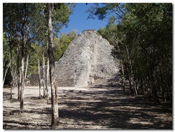
Morning: Drive out from Merida--the drive is around 2.5 hours, so we recommend you bring some reading material. Upon reaching the site, you will notice that the jungle has not been completely cleared away, making it easier for one to step back in time while viewing the ruins. The site, covering a large 42 square miles, is a hotspot for the adventurous traveller, as it gives the feel of being back in the jungle with those who once inhabited the now ruins of Coba. As you begin to explore the site as a whole, you will begin to understand the truth behind Coba's name, meaning "water stirred by the wind," in the Maya language, because Coba neighbors a group of shallow lakes. As you make your way through the site, you will notice that the site structures are scattered along a system of sacbe, or "white roads." Each sacbe is practically identical, built to the exact architectural guidelines of a base of stones three to six feet high, a 15 feet tall side, completely covered with white mortar. Approximately 50 sacbe have been found spanning the Yucatán Penninsula, but there are more in Coba than in any other location. As you wander, also be sure to mark the collection of stelae, or carved stone pillars, throughout the Coba area. In the Coba are are 32 Classic period stelae.
Afternoon: After you have completely explored the site as a whole, specifically visit the pyramids on the site--Nohoch Mul and La Iglesia. Nohoch Mul is the tallest pyramid on the site, measuring 138 feet in height. At the top of the pyramid is a small temple with a carving of a god descending to earth, exposing the connection the divine were thought to have with the Maya people. La Iglesia, translated as "The Church," is the second highest pyramid at Coba. If you climb to the top of the pyramid, you will be able to see over the surrounding jungle to one of the neighboring lakes, Lake Macanxoc. Finally, visit the Cunjunto Las Pinturas, a temple at Coba named for the stucco paints that once lined its walls. Remnants of the paintings, in chipped layers of yellow, red, and blue, are still seen in the top corner of the temple.
Evening: Return to Merida and drive to the Merida Rejon Airport for a 5 hour flight to the San Pedro Sula Airport in Honduras. Spend the night in San Pedro Sula.
Day 5

Copán
Morning: Drive out to Copán, a site 2 hours from San Pedro Sula. Copán, a UNESCO World Heritage Site, the massive architecture built in the city's golden age from 420 to 820 A.D. under 16 rulers serves as a reminder of Mayan greatness. In fact, the site of Copán is one of the most spectacular achievements of the Mayan Classical Period because of its numerous architectural and sculptural monuments that express elaborate designs in magnified proportions. However, the ruins of Copán act as more than just a legacy of architectural prowess, but also as a legacy of art and learning in Maya culture. First go to the Acropolis at Copéan, as its mass of rubble with the world's largest archaeological cut will help you understand and truly appreciate the engineering of Mayan architecture before continuing on to other attractions. In the walls of the large cut, one can distinguish the floor levels of previous plazas the Mayans built over, reflecting a prodigious amount of effort because of the size of the ground it leveled and paved and then for the great volume of the acropolis that is elevated some 30 meters from the ground. The cut, caused by the course of the Copán River through the Acropolis before the river's course was diverted, exposes traces of masonry platforms, human remains, and domestic activities, suggesting that in very ancient times Copán was not a ceremonial center as it was for the Maya, but dwellings of the elite. Before moving on to other sites, explore the small patios or courts that the Acropolis is separated into, the West Court and the East court. The West Court contains a replica of Altar Q, a marker of the entrance to a structure where jaguars were sacrificed. The East Court, whose structures long since disappeared with the current of the Copán River, is the site of the archaeological cut that gives detail to Mayan architecture.
Afternoon: After you have examined the architecture of the acropolis and the courts around it, visit the Hieroglyphic Stairway, the longest known text in the Mesoamerican world before the arrival of the Spanish. The Hieroglyphic Stairway is a testament to the Mayan hieroglyph writing system, one of the first of five writing systems ever developed. Taking in the Hieroglyphic Stairway, it is easy to sympathize with the historians who worked so long to crack the Maya code of language, as the Mayan glyphs are extremely complicated. Next, visit Rosalila, the Maya's best preserved temple and the principal religious sanctuary at Copán in the late 6th century A.D. Rosalila consists of three stories and measures to just over 42 feet tall. The first level consists of four long, narrow rooms--the fourth room, the central, intimate space, is reached only by walking through the first three rooms. Within these rooms, the Mayas carried out religious ceremonies and rituals. According to artifacts within the temple, such rituals probably included human sacrifices and blood-letting rituals, as flint knives were found for sacrifice along with stingray spines used as perforators.The upper levels of the temple display religious artwork in vibrant colors. As a whole, the temple is situated over a nearly 10 foot terrace pyramid called "Azul."
Evening: Drive back to the San Pedro Sula Airport and take an evening flight to the Flores Mundo Maya Airport in Guatemala, a 2 hour direct flight. You will spend the night in Flroes, Guatemala.
Day 6

Tikal
Morning: Drive from Flores, Guatemala to Tikal, a mere hour drive. Tikal, now a UNESCO World Heritage Site, was once a major city of the Maya Empire, home to over 10,000 individuals in its six square miles. It is one of the few Mayan cities that peaked in the pre-classic as well as the classic eras. Tikal National Park, the first wildlife preserve of its kind in Central America, preserves 3,000 temples, palaces, shrines, ceremonial platforms, residences, ball courts, terraces, and plazas. Begin exploring Tikal by visiting the Great Plaza, a plaza surrounded by Tikal's two largest temples. The Great Plaza is accredited to Ha Sawa Chaan-K'awil, Tikal's ruler in the 9th century. Sawa Chaan-K'awil framed the Great Plaza with these two monumental temples--he completed Temple 2 during his lifetime and left the construction of Temple I, also known as the Temple of the Giant Jaguar, for his son to complete. The Temple of the Giant Jaguar was made Sawa Chaan-K'awil's own burial ground. The Temple of the Giant Jaguar's construction finished in 870 A.D., and the temple towered over Tikal at 145 feet tall. Temple 2, stands just shorter than the Temple of the Giant Jaguar at 122 feet, and was erected facing East toward the rising sun; meanwhile, the Temple of the Giant Jaguar faces west towards the setting sun. The Temple of the Giant Jaguar faces west because it was considered the portal to the Underworld by the Mayans, for within the temple is Ha Sawa Chaan-K'awil's tomb, in which he was expected to rebirth in the afterlife in accordance with Mayan religious beliefs.
Afternoon: Once you have thoroughly explored the Great Plaza of Tikal, you will go on to explore one of the city's four acropolises. Acropolises are massive constructions of ceremonial buildings on a large scale; within Tikal, these acropolises were seats of administrative and political power, and often the burial sites of prominent rulers. The four acropolises in Tikal are: The North Acropolis; The Central Acropolis; The South Acropolis; and the East Acropolis. For your journey with Meanders™, you will visit the North Acropolis, which is a wealth of stone monuments. The North Acropolis is one of the most ancient areas in the city, containing evidence of the first settlers in Tikal, who came to the area in c. 800 B.C. The acropolis was built atop a large artificial terrace that supported numerous buildings. Scattered throughout the North Acropolis are also stelae and altars portraying the rulers of Tikal and recording historic events from the times of the Maya Empire.The theory that the North Acropolis was a burial site was confirmed when archaeologists found the burials of Huh Chaan Mah K'ina (or Curl Nose), K'awil Chaan (Stormy Sky), and a noble woman buried with paintings of wealthy nobility, jade stones, and other opulent items. Some of these artifacts from the burials can be found in the on-sight museums at Tikal.
Evening: Return to Flores Mundo Maya Airport for an evening flight to Belize International Airport, a quick one hour flight. Spend the night in Belize City.
Day 7

Caracol
Morning: Drive out to Caracol, an archaeological site 3 hours away from Belize City by car. The Mayan city of Caracol is the largest Mayan ruin site in Belize. Archeologists estimate that Caracol, during its peak (between 550 A.D. and 900 A.D.), was home to over 150,000 people in its five square miles and had 35,000 buildings, three times the buildings found in Guatemala's Tikal. Today, the partially excavated site of Caracol is open for walking tours and trips on horseback. Be sure to pack all food and water you will need for the day, as Caracol is in the middle of miles of uninhabited virgin rainforest and is far from the conveniences of the modern day. Anthropologists Arlen and Diane Chase of the University of Central Florida have spent decades hacking through the tangled undergrowth that engulfed the city, but still many of the ruins remain uncovered, only detectable through flyovers using Light Detection and Ranging (LiDAR) to see what structures are left to be uncovered. Some of the temples uncovered by the LiDAR technology and that has now been excavated to see without the aid of a 3D map is the Caana temples and palaces. Visit these temples amidst the ruins of Caracol. These temples were called the "Sky Place" temples. The temple "Caana" rises 42 meters above the ground level of Caracol's plaza. To this day, the temple Caana is the largest man-made structure in Belize.
Afternoon: After having explored the Caana temples, continue with a general tour of Caracol. Visit many of the 70 formal tombs excavated and see the hieroglyphic texts gracing the site's stelea, altars, ball court markers, capstones, and wall facades. Search through the beaten-back undergrowth of the site that for so long kept Caracol a secret of the jungle to discover the thousands of new structures the LiDAR technology under covered, the 11 new roads, the tens of thousands of agricultural terraces, and a number of hidden caves throughout the city that we now know to stretch past the originally uncovered 5 square miles to a sweeping 68 square miles. Before leaving Caracol, visit the on-site museum that was constructed at the end of the 1998 field season. The museum contains some of the artifacts uncovered at the site as well as the history of the site, both in ancient times and as a modern archaeological site. The museum also gives a brief overview of the Maya, much like the overview located on our Meanders™ website.
Evening: Drive back to the Belize International Airport for a 3.5 hour flight to Mexico City, Mexico.
Week 2
Day 1

Mexico City
Morning: In the morning, travel around Mexico City, the city under which the great Aztec capital of Tenochtitlán is buried. Almost all evidence of the past city of Tenochtitlán has vanished, having been razed by the Spanish invaders led by Cortez in 1519 to 1521; what remained of the razed city was completely built over by Cortez, who wished to destroy all evidence of the old order. However, one prominent ruin remains. The Templo Mayor was the main religious building of Tenochtitlán, capital of the Aztec Empire. The temple was 15 stories, towering at 197 feet tall, at its height--the ruins today do not hold such a grand stature and are considerably smaller. The Templo Mayor consisted of two twin temples, both made of lime plaster and volcanic rock, to honor two Maya gods. One of the twin temples honored the god of rain and agriculture, called Tlaloc, while the other twin temple honored the god of war and the patron god of the Mexica people, called Huitzilopochtli. Both of these gods required constant human sacrifice to be pleased, so during the final phase of construction thousands of people were sacrificed to ensure that the gods were pleased with their new temples. Specifically, Tlaloc required children sacriced through drownings, according to Maya legend, and Huitzilopochtli required the spilling of warrior blood. Once the temples were constructed, they remained a main site of violent, bloody Aztec religious rituals. Rituals that occurred within the temples included human sacrifice, ritual blood letting, and less violent rituals as well, such as the burning of copal (a tree resin), and worshiping the gods through musical expression. The architecture of the temples was equally as awe-inspiring as the stories behind its construction. The temple represented the Hill of Coatepec, a hill where the Mexica people believe their patron god, Huitzilopochtli, was born. It was very important to the Aztecs that this temple never sink and so dishonor the gods. To prevent poor maintenance of these temples, the Aztecs rebuilt the temple seven times, each rebuilding adding a stage on top of the previous stage. Adding so many layers to the temple ensured that, even if the temple sunk a little overtime in the swampy island of Tenochtitlán, it would always retain a hefty stature to honor the temples' deities.
Afternoon: To compliment your visit to the Templo Mayor, visit the Museo del Templo Mayor, the museum dedicated to preserving and exhibiting the archaeological remains excavated over the course of several years by the Templo Mayor Project. The useum was inaugurated on October 12, 1987, and it displays artifacts uncovered on site from 1978 to present day. The museum has eight halls to explore, with thousands of objects inside. The artifacts include sculptures, reliefs, and other elements found in the digging sites. The museum also has a down-scaped reproduction of the Templo Mayor in the form of museum displays. The walls of the museum even mirror the religious dedication of the twin temples--the halls in the south wing are dedicated to Huitzilopochtli, god of war, related to the Sun, and those in the north wing to Tlaloc, god of rain.
Evening: Drive to Teopanzolco, located in present-day Cuernavaca, Morelos, Mexico, where you will spend the night. The drive should be only 2 hours.
Day 2

Teopanzolco
Morning: Explore the site of Teopanzolco, located in the city of Cuernavaca, Morelos, Mexico. The Tlahuica people lived in the ancient city of Teopanzolco after settling there in the mid-13th century. However, shortly after their settlement, the Aztecs invaded and conquered the city of Teopanzolco, adding it to their ever-expanding empire. Before visiting the main attraction of Teopanzolco, its Great Pyramid, take a general tour of the site to better understand the architectural themes of the site. Teopanzolco consists of a large, public plaza surrounded by various structures, including the Great Pyramid and numerous low platforms. The architecture is dated to the Early Aztec period based on ceramic items recovered from within some of the temples. Across the plaza from the Great Pyramid is a row of low stone platforms that were bases for altars. Under these altars have been found a mass sacrificial burial consisting of skulls from decapitated individuals and offerings of pottery vessels and other items, revealing once more the prevalence of human sacrifice in Aztec religious rituals.
Afternoon: Though the old city is mostly covered by the new, just as Tenochtitlán is mostly covered by modern Mexico City, one main ruin remains protected in the city. This ruin to explore at Teopanzolco is the Great Pyramid of Teopanzolco. The main structure of the pyramid is a large double pyramid built in the style of the larger pyramids in central Mexico, such as Templo Mayor in Mexico City. In fact, both the Great Pyramid and the Templo Mayor were built in the Aztec twin-stair pyramid style to honor two deities, for just like the Templo Mayor, the gods worshiped by this site were the gods Tlalcol and Huitzilopochtli, whose shrines are still visible within the temple. Having just visited and explored the Templo Mayor, you should gain greater appreciation for the similarities between Aztec architecture.
Evening: Stay the night at your hotel in Teopanzolco.
Day 3

Xochicalco
Morning: Drive from Teopanzolco to Xochicalco--the drive is only 30 minutes. Xochicalco, a UNESCO World Heritage Site, was an Aztec city founded in the 7th century A.D. on a series of natural hills. Xochicalco was founded during a period of political instability when easily defensible sites were the most pragmatic places to settle, so Xochicalco was built in the hills to be protected from enemy attacks. The highest hills were the core of Xochicalco, housing many public buildings, though the lower hills were often settled as well. To cope with their hilly environment, the inhabitants of Xochicalco used terrace farming to sustain their population. As you tour the site of Xochicalco, you will notice that it is broken into three distinct levels. The lower part is encircled by walls with defended entrances to protect against invasions; the buildings situated here were mainly residential. The intermediate level housed the Plaza of the Stele of the Two Glyphs, more residential structures, and the southern ball court, which is the largest at Xochicalco. As you explore the site as a whole, pay special attention to the ball court, which is reached by a wide causeway, lined by a series of 21 calendar altars, recording the months (and in one case days) of the ceremonial year. Beyond the ball court is the Palace composed of residential rooms, kitchens, workshops, storerooms, and a temazcal (steam-bath) ranged around a series of patios.
Afternoon: Go on to explore the group of temples and other monumental buildings on the highest of the three levels that was designated specifically to the ruling class and nobles. These monuments are grouped around the main Plaza. To the east of the plaza is a complex of three structures: a rectangular surface that opens onto a sunken patio and that is only accessible from the roofs of the rooms; a large patio closed on three sides by narrow galleries; and the east ball court. Explore the east ball court, paying particular attention to the monumental ramp paved with stone slabs engraved with images of birds, reptiles, insects and mammals, known as the Ramp of the Animals, that divides the court. Lastly, explore the Pyramid of the Plumed Serpents located in the middle of the plaza. The pyramid is so named for the four facades around the pyramid sculpted with representations of enormous plumed serpents, the Quetzalcoatl of Teotihuacan. Their bodies frame seated figures, most likely priests, rulers, and astronomers, explaining the Aztec focus on the arts and sciences as part of their advanced culture. The upper walls of the temple bear figures that have been interpreted as warriors, signifying the Aztec prowess in war.
Evening: Return to your hotel in Teopanzolco, where you will spend the night.
Day 4

El Tepozteco
Morning: Drive out 40 minutes from Teopanzolco to El Tepozteco. Once you reach the site perched on cliffs overlooking the modern town of Tepoztlan, all visitors must hike a trail leading off the end of the main street to the site (the climb takes over an hour). Before making this hike, we recommend exploring the modern city of Tepoztlan. During the time of the Aztec Empire, Tepoztlan was an independent city-state, and the Aztec town probably lies under the modern town center just as Mexico City covers Tenochtitlán. Various small Aztec-period structures have been located in the modern town, though no extensive excavations have taken place as at El Tepozteco. Aside from viewing the various period structures, make sure to visit the sixteenth-century church and convent in Tepoztlan (now run by INAH and open to the public) where excavations of the churchyard uncovered Aztec-period. After exploring Tepoztlan, forge the hike to El Tepozteco.
Afternoon: Once you teach the site of El Tepozteco, visit the major feature of the site, the Temple of Tepozteco. The small temple is raised on a platform and most known for its carved inscriptions depicting various religious themes, again emphasizing the importance of religion in Aztec daily life. These carvings depict offerings and sacrifices related to the gods of pulque (an alcoholic drink used by the Aztecs), exposing once more the theme in Aztec religion that sacrifices and retribution must be made to all gods to ensure order. The temple is presumed to have been built in Early Aztec times (1100 A.D. to 1350 A.D.), yet the temple is also thought to be attributed to the Mexica Ahuitzotl who came later than the Early Aztec times. Archaeologists had thought that Ahuitzotl was the builder of this temple because a stone panel with the name glyph of Ahuitzotl was recovered at the temple (the panel is now on display at the National Museum of Anthropology in Mexico City). Since the temple was built before Ahuitzotl's time, the king probably sponsored a rebuilding of the structure during his later reign. Before leaving the site of El Tepozteco, you should also observe the series of residential terraces near the Tepozteco Temple that hold artifacts of Early Aztec-period occupation. The terraces are thought to have been a residential area for priests or caretakers of the temple. The terraces are immediately above the steep cliffs, and have an excellent view of the town and valley of Tepoztlan; be sure to snap a few photos for the folks back home before departing the site!
Evening: Drive 2 hours to Cholula, where you will spend the night.
Day 5
Cholula
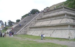
Morning: Cholula is located just outside the city of present-day Puebla, Mexico, whose center is recognized as a UNESCO World Heritage Site. In the ancient times of the Aztec Empire, Cholula was a sacred city and major commercial center. Being an important sacred center, even the Aztec leaders went to Cholula to be annointed. Pilgrimages were made to the city for times of worship. While Cholula is famous as a ruin of the Aztecs, the area of Cholula has probably been inhabited for over 3000 years, and its main temples from over 2,000 years ago, so it is still unclear whether the Aztecs can be accredited for all of the city's glory. As the city rose to power, developing from a village to a city of importance, many of the powerful cultures of Mexico had their turn to rule it, including the Olmecs, the Toltecs, and later the Aztecs. Each group that at one point dominated the city added to its largest architectural feat--the Great Pyramid of Cholula. The Great Pyramid of Cholula is the largest pyramid by volume in the world, and the largest monument ever constructed. The magnitude of this architecture can probably be explained by the fact that three of the great civilizations of Mexico added to it at one point or another, resulting in a magnificent expression of architecture combining the styles of the Olmecs, the Toltecs, and the Aztecs. The joint architectural feat also emphasizes the timeline of Aztec rule--there were other thriving civilizations before the dominance of the Aztecs. One of the most interesting aspects of the pyramid to explore is the 5 miles of secret tunnels dug through the temple. Visitors can explore these tunnels alone or with a guide to uncover the mysteries of the cultures that built the Great Pyramid of Cholula.
Afternoon: Now having seen the Great Pyramid of Cholula and explored all of its passageways, journey to the top of the hill from the pyramid to explore the Christian church which the Spanish invaders built above the pyramid as a symbol of the religious conquest of Mexico--the Spaniards wanted to assert their own Christian faith over the "barbaric" polytheism of the Aztecs. The church, called the Iglesia de Nuestra Señora de los Remedios, translating to "The Church of our Lady of Remedies," is more opulent in design that the Great Pyramid--the church was decorated with gold leaf and designed in the neoclassical style.
Evening: Drive back to Mexico City to spend the night, a 2 hour journey.
Day 6
Teotihuacan
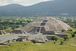
Morning: Drive 45 minutes north of Mexico City to Teotihuacan. Teotihuacan, now a UNESCO World Heritage Site, was not specifically an Aztec city. By the time the Aztecs took over the city, it had been in existence for over 1,600 years. To claim the site as their own, the Aztecs declared Teotihuacan the spot of the current world's creation, the place where the gods had sacrificed themselves in order for the world to be recreated. The Aztecs even gave the site its name of Teotihuacan, roughly meaning "birthplace of the gods." Since the Aztecs believe Teotihuacan was the universe's birthplace, they named the two main temples in the city the Pyramid of the Sun and the Pyramid of the Moon. After taking in the whole of the site, go visit the Pyramid of the Sun. The Pyramid of the Sun towers over the other architectural monuments at Teotihuacan, sprawling 215 feet into the air--the pyramid is so large, it is ranked the 3rd largest pyramid in the world. The temple is dedicated to the Sun god of the Aztec religion, called Tlaloc, the god of the Sun as well as the god of fertility and rain. The pyramid was constructed on a lava tube cave, mostly likely when the city reached its peak before the dominance of the Aztecs. However, the site was sacred to the Aztecs, and they continued to use the temples as their own for ritual practice. The pair to the Pyramid of the Sun is the Pyramid of the Moon, a 138 feet tall temple dedicated to Chalchihuitlicue, the goddess of the Moon as well as of the goddess of the lakes and streams. The Pyramid of the Moon, too, was not built by the Aztecs but still used by them as a sacred site for religious practices. At their peaks, the two temples were thought to be plastered and painted in bright red.
Afternoon: Next visit the Pyramid of the Feathered Serpent, the third largest pyramid in Teotihuacan. Although significantly smaller in size than both the Pyramid of the Sun and the Pyramid of the Moon, the Pyramid of the Feathered Serpent is one of the city's most elaborate monuments. The principal facade of the temple, uncovered during Manuel Gamio's excavations between 1917 and 1922, had been covered with carved blocks, including impressive three dimensional sculptures. These facades of stone carvings included a series of large sculptural heads he facade of the temple evidences a remarkable amount of high-energy expenditure work by a multitude of men, evidencing the architectural prowess of the Aztecs, or the society that built the temples before the Aztecs. The Pyramid of the Feathered Serpent complex consists of the pyramid, raised on a stepped platform, it's temple placed on top of the pyramid, and the Adosada platform later built onto the main facade of the pyramid. Fortunately, the principal (western) facade of the pyramid was covered by the Adosada platform in ancient times, so when the facade was uncovered it was in excellent condition, whereas many of the other facades had been destroyed. The preserved facade allows us to see today the depicted images of feathered serpents and a form of a sacred headdress, evidencing the importance of ritual, mythic religion in Aztec society.
Evening: Return to Mexico City to spend the night.
Day 7

Calixtlahuaca
Morning: Drive out 1 hour from Mexico City for a day-trip to Calixtlahuaca. Calixtlahuaca, located in the Toluca Valley of highland central Mexico, is one of the very few Aztec-period urban sites where both monumental architecture and large residential districts are preserved today. The duality of structure preserved at Calixtlahuaca makes the site an important study in Aztec architecture for its purposes in royal and religious purposes as for its importance in daily life. Though the site's architecture and sculptures mirror the styles seen in other urban Aztec sites, its layout is radically different from other Aztec cities. The first "attraction" of the site will be walking around the site as a whole to see how the layout differs from the other sites you have visited. You will notice that most of the settlement at Calixtlahuaca is scattered across the slopes of Cerro Tenismo, a small relict volcano, and into the valley floor below the volcano. You will also notice that the hills are covered with stone terraces, many of which have very dense surface artifact concentrations.T he hills of the residential zones are so sliced with terraces for maximum agricultural benefit, a technique found in many Aztec sites. The site, 317 hectares in area, is the third largest Aztec-period city in Central Mexico, so you will need the whole morning to explore it thoroughly.
Afternoon: Visit the largest and best known building of Calixtlahuaca, titled Structure 3 by archaeologists. Structure 3 is a circular temple whose early excavation yielded a life-sized stone sculpture of Ehecatl, the Aztec god of wind. The temple, most likely dedicated to Ehecatl, since his sculpture was found within, is a perfect geometric shape. Being a circle, it is infinite, having no beginning or end, causing some to theorize that the temple is a representation of the gods, infinite in power. Once you have thoroughly explored the temple, circle back to the residential areas and explore some of the houses to get a sense of the everyday life in the Aztec world as well as the extravagant, ritual life of Aztec religion.
Evening: Fly from Mexico City to Cuzco, Peru--be sure to sleep on the 7 hour flight so that you are ready for a full day of sightseeing once in Peru!
Week 3
Day 1

Machu Picchu
Morning: Drive from Cuzco to Ollantaytambo (a 1 hour drive). From Ollantaytambo take the train into Machu Picchu (a 1.5 hour journey). You will arrive at the site park and walk up to the top of the mountain crest in the Peruvian Andes on which the site sprawls, 8,000 feet in the air. Machu Picchu, named one of the New Seven Wonders of the World and a UNESCO World Heritage Site, like Chichen-Itza, is the most famous archeological ruin in the Western Hemisphere and an iconic symbol of the power and engineering skill of the Inca Empire. The "Lost City of the Incas" was discovered in 1911 by Hiram Bingham, an American explorer who made the site public with the guidance of indigenous farmers. Though theorized about for some time, the site remains an enigma to historians today. It seems impossible to determine why it was abandoned by the Inca people over 400 years ago--throughout the city, it appears as though the stones were in the middle of being placed when work was suddenly halted, leading many people to question why the work was so abruptly relinquished. The quality of the stonework suggests that Machu Picchu was constructed at the orders of royalty, but not much else has been derived from the in-tact ruins of the site. Don't leave your mind to be swayed by the accounts of theorizing historians! See the sites for yourself--visit the fountains, small pools, temples, homes, and alters cut out of granite, stone structures numbering over 200 across the site. See the great engineering and architectural prowess of the Inca, and theorize for yourself why such artistry was left behind. On your tour of the site as a whole, visit the Huayna Picchu, the mountain on which the superior priest of the Incas and the virgins of the empire, known as the acllas, would worship Inti, the sun god, every day. This site has remarkable views that you will want to capture to display once back home in the States. Huayna Picchu is also a brilliant reminder of the polytheistic religion of the Inca, as their chief deity of the sun god was one of many worshipped figures.
Afternoon: Circle back from the path leading to Huayna Picchu to visit the Temple of the Moon, a cave temple carved directly from the stone side of the mountain. The cave in an excellent example of Incan engineering and mathematical skill, as planned geometric shapes are carved in the stone. The Temple of the Moon is thought to have been a place for the ritual gatherings and ceremonies specifically of the Incan elite, as a throne, probably from a member of the royal family, is carved from the stone within the cave. After exploring the Temple of the Moon, visit another prime combination of Incan architecture and mathematical skill at the Temple of the Sun. The Temple of the Sun is constructed in a semicircle, and has a tower above it with a trapezoid-shaped window. The prevalence of distinct geometric shapes in the architecture shows the detailed, planned approach the Incas took to architecture, using it as a base for their knowledge of engineering and mathematics. For all practical purposes, however, the temple was a solar observatory where pottery was placed in the windows to bring the position of the sun into equilibrium in order to preform rituals perfectly. (It should be noted that these rituals did not include human sacrifice like the Maya and Aztec rituals often required, but relied primarily on animal sacrifice.) Even the placement of the temple as a whole is determined by astronomy--the Incas placed the temple at the highest point of Machu Picchu, a place where they could "reach" the sun during their rituals. Thus, not only did the temple emphasize the breadth of knowledge the Incas possessed in mathematics, but also the span of their talent in astronomy.
Evening: Return on the train to Ollantaytambo, where you will spend the night.
Day 2

Machu Picchu/Choquequirao
Morning: Return to Machu Picchu by train from Ollantaytambo. Once you reach the site of Machu Picchu, take in again the granite mastery of the Incan architects who forged Machu Picchu. Review the fountains, the temples, the residential areas, and the altars to solidify your theories on the enigma of Machu Picchu as you cross the site. Once on the outskirts of Machu Picchu, a Meanders™ 4x4 vehicle (with drive) will take you to Choquequirao, Machu Picchu's sister city on the opposite side of the Machu Picchu Park. Since Choquequirao is located on the opposite end of the park, you should expect a long drive--don't forget to bring water and snacks for the journey!
Afternoon: Upon reaching Choquequirao, you will notice a striking similarity to the preserved ruins you viewed at Machu Picchu. Though Machu Picchu is the more famous of the two sites, after walking around the ruins of Choquequirao it will become clear that Choquequirao is probably the larger of the two sites. However, Machu Picchu's greater fame could be because only 30 percent of Choquequirao's original complex is believed to have been uncovered in excavation. Walking around Choquequirao, take in the fascinating ruins around the central plaza, noting that the layout of the site mirrors that of Machu Picchu, and experience the breathtaking views of the Inca site. You should also visit the several sets of ancient agricultural terraces decorated with stone llamas that were uncovered in a 2005 excavation. Be sure to set out with enough time to reach Machu Picchu before nightfall--Meanders™ will provide a helicopter to take you back to Machu Picchu by dark.
Evening: Return to Ollantaytambo by train to spend the night.
Day 3

Vitcos/Yurak Rumi
Morning: Drive 2.5 hours from Ollantaytambo to the site of Vitcos. Vitcos was discovered in 1911 during a Yale archaeological expedition to find Vilcabamba, the "Lost City of the Incas," the secret mountain stronghold used during the 16th century rebellion against Spanish rule; the expedition was directed by Hiram Bingham. (It is interesting to note that Bingham also discovered and excavated Machu Picchu on his quest, mistaking it for Vilcabamba.) When you arrive at Vitcos, you should first explore the main palace, an enormous structure whose front walls measure more than 200 feet wide. Pay careful attention to the stonework around the palace, particularly the fine stonework around the palace doors.
Afternoon: The rest of your day at Vitcos, however, should be spent hiking to and then exploring the Yurak Rumi, or the "White Rock." The Yurak Rumi is the real draw of Vitcose. It is an intricately carved granite boulder measuring the size of a city bus, and it was once one of the holiest shrines in the Inca Empire.
Evening: Return to Ollantaytambo for the night.
Day 4

Ollantaytambo
Morning: In the morning, leisurely explore the streets of Ollantaytambo, experiencing the combination of both the old world and the new world. Ollantaytambo was, in 1536, the site of the Inca's greatest military victory against the invading Spaniards, leading to the city today retaining more of its Incan architecture and culture than most Incan sites. The Incan people fought hard to protect their city of Ollantaytambo, allowing its works to be preserved to modern day. First, meander through the city and view the original Inca walls that the city maintains. Do you notice a difference in the masonry? Are you beginning to be able to tell the difference between the precise stacking of stones from Incan masons that fit together like puzzle pieces from the modern stone replicas? As you walk down the streets, appreciate also the great planning of Ollantaytambo. Then, realize that the grid is the original Incan street grid.
Afternoon: Continue your stroll through the city and notice the pattern that the area is dominated by long, ancient stone walls that once divided groups of homes around communal courtyards. Recall all you have read about Incan society and wonder if such division was implemented by the seemingly omnipotent government. Next, visit the imposing set of stone terraces that loom above the town, capped by six mysterious pink granite slabs. Automatically recognize the terrace design that you have seen throughout the Maya, Aztec, and Inca ruins. Also, as you stand atop these ruins, looking down on the town you have just uncovered, imagine the brave Inca assaulting their Spanish invaders with slingshots and arrows from this point and appreciate that you are standing where history was made.
Evening: Drive back to Cuzco, where you will spend the night.
Day 5

Sacsayhuaman/Cuzco
Morning: Drive to Sacsayhuaman from Cuzco--the drive is only a few minutes, so you may walk to the site if you wish (the walk should take approximately 30 minutes at a leisurely pace). Once at Sacsayhuaman, turn back to get a sweeping view of the city of Cuzco, which the Sacsayhuaman ruins overlook. The large complex of ruins at Sacsayhuaman is arguably the greatest Incan ruin after Machu Picchu. Sacsayhuaman, recognized as a UNESCO World Heritage Site, is surrounded by the Ausangate, Cinca, and Pachatusan Mountains. The strategic location of the Sacsayhuaman site has led many historians to believe that it was a royal retreat or a fortress, or possibly both, located within the geographical boundaries of the mountains. The fortitude of the walls at Sacsayhuaman have also helped historians conclude its purpose--the zigzag walls are built with some of the largest stones in Incan masonry, some weighing up to 300 tons. The site is also a study in Incan architectural excellence. the stones all fit together perfectly, a fit that took an estimated 50 years and 20,000 men to perfect. The men use would have been subjects of the labor levy, or mita, which decreed that all Incan people owed the government two months of labor per year--this tax allowed the Incan government to access large portions of their male population at once to achieve such grand architectural feats. Other evidence supporting the theory that Sacsayhuaman was a fortress are the three fortified towers, known as Muyucmarca, Sallacmarca, and Paucamarca, on the top of the main structure. Sacsayhuaman is further guessed to be a fortress because it is shaped like a puma, and a translation of Sacsayhuaman means puma, an animal that the Inca believed was a watchful protector. The Incas may have wanted the puma to guard Sacsayhuaman as one would want a fort to be guarded. While visiting the ruins as a whole, make sure you visit the temple at Sacsayhuaman; this temple was an important place of worship and ritual celebration for the Incas. In the temple, celebrations such as the Inti Raymi feast took place, highlighting the celebratory and ritual nature of Inca religion.
Afternoon: Return to Cuzco to explore the modern city and contrast the old and new worlds. Does the city of Cuzco hold any of the geographic advantages that the "fort" of Sacsayhuaman holds? Cuzco is named as the "navel of the world," as it was a center of cultural, spiritual, and monetary wealth for the Inca Empire. The holy city had four roads that led out from its central plaza in the cardinal directions, each road pointing out to the four corners of the Inca Empire. To say that all roads led to Cuzco would be cliché, but also ring true. Cuzco was the epicenter of the empire, its residences the palaces of the Incan rulers, though most of these original buildings have been destroyed in conquest. Still, as you travel around the city, you can still see the original walls of some of the Incan structures, walls you will recognize for their classic, precise Incan masonry. The walls that still stand in Cuzco today are a testament of Incan architectural skill--the walls have withstood conquest as well as natural disasters, including many major earthquakes. The holiest site and attraction to see while exploring Cuzco is the Koricancha, or sun temple; as you look on at this temple, imagine it in its former glory before the Spanish invasion when it was covered in sheets of gold.
Evening: Spend the night in Cuzco.
Day 6

Pisac
Morning: Drive out to Pisac from Cuzco (the drive should only be 30 minutes). Before going to the ruins of Pisac, explores the markets of the city surrounding the ruins. The whole town of Pisac is encompassed by the street market that sprawls through it, where vendors sell crafts from all over Peru, Alpaca wool clothing, and fresh produce. As you wind between the wooden stalls bursting with colorful patterns and brimming with delicious aromas, remember all that you have learned about Incan society. See how the present mingles the past in ways, how the Incan legacies of weaving and metal orgy still live on in the crafts of these vendors. Give yourself the gift of time to explore this market, to experience the sounds, sights, and smells of Pisac today. Take an early lunch in the market before visiting the ruins of Pisac. It should be noted that while the market place has become a tourist destination, it still provides an "old world" feel and insight into the native life of modern Pisac.
Afternoon: After your trip to the market, continue on to the ruins of Pisac that overlook the Urbamba river. On site, you will be exposed to the agricultural values of the old Inca society through the waterworks, terraces, and colcas present. The terraces are remnants of the terrace farming method the Incas employed along their mountainous lands to achieve flat growing spaces for crops, and the waterworks would be aqueducts and other architecture to manipulate water and bring it to the terraces. The colcas, meanwhile, are the storage houses where the Incan government would keep agricultural surpluses to dole out in case of an emergency in the provinces, a tactic that put all control in the hands of the Incan government who literally controlled the hunger of the nation. Another site to see while in Pisac is the Amaru Punku. The Amaru Punku is the wall surrounding and securing Pisac--Amaru Punku translates to the "snake gate," named such probably because it coils around the site like a serpent. You should also stop at the Inca cemetery, the resting place of over 10,000 tombs. The bodies in these tombs where mummified, reflecting the Incan belief in rebirth in the afterlife, as the wrapped mummies were preserved with food, jewels, and weapons for their next life, much like the Egyptian pharaohs were prepared. The cemetery is a solid reminder of the Incan religious beliefs and their advanced medical knowledge that helped them preserve their bodies for the afterlife.
Evening: Fly from Cuzco to Lima, where you will spend the night. The flight is only 1.5 hours.
Day 7

Isla del Sol
Morning: Set out in time to catch the sunrise on the granulated shore of Isla del Sol. The hues reflecting off the water's turquoise surface will be enough to convince you that this island situated in the middle of Lake Titicaca really is the divine grounds where, according to the Inca creation myth, the all-powerful sun god, Inti, first emerged as the waters that once covered the earth receded.
Afternoon: Explore the island, which is located on the Bolivian side of the lake. The island is home to dozens of Inca and pre-Inca ruins connected by hiking trails. You will enjoy the peace and serenity of these natural trails, as no cars are allowed on the island. As you visit the island, allow your mind to step back in time to match the view of the ruins--truly come to an understand of Inca life, an understanding deeper than the words on these page, fuller in knowledge than the overview on our homepage. Freely explore the paths of the island, but make sure you stop at the most impressive sights like the labyrinth called Chicana and the sacred Titi Khar’ka—Rock of the Puma—which gave the lake its name.
Evening: Fly back to the USA after a full day at the island, having gained a thorough knowledge of the three great Amerian civilizations: the Maya, the Aztecs, and the Inca.
